Map of the highest peaks in Ontario. Created in Mapbox using Mapbox GL JS.

All in Post
We make maps of Toronto. We will be posting a map a week for all of 2020. Follow along.
Over the winter we’ve had our heads down working on a project with our friends at The Local. Our role was to provide interactive mapping describing how socioeconomic differences across the city align with health outcomes. The process involved several tools including QGIS and GDAL, TippeCanoe and Mapbox GL.
Using the Ministry of Natural Resources and Forestry’s digital elevation model (DEM) we visualized the elevation across the whole province of Ontario.
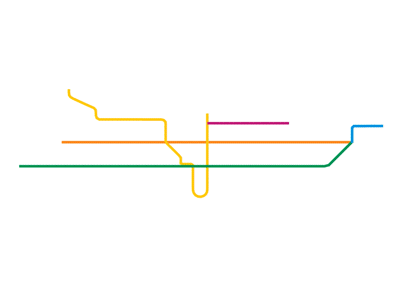
Inspired by one of our favourites, Massimo Vignelli, we designed a map of rail transit in Toronto operated by the TTC (subways and streetcars)
Heavily inspired by the New York Times’ incredible A Map of Every Building in America, we have created Every Building in the Greater Toronto and Hamilton Area (GTHA).
This map is based on the City of Toronto’s Annexation Map. The City of Toronto Archives have a high quality digital version of it here.
Wikipedia has a detailed timeline of Toronto’s amalgamation and annexations between 1791 and today. This map was made possible because of Mapbox, Turf, and QGIS.
I was always curious, when looking up at the TTC's subway map, what it actually looked like. I ended up recreating it to scale one day and was surprised by the response. Since the TTC is updating the map, I thought I would take another look at it, but with some analysis this time. Using Bernhard Jenny's MapAnalyst I was able to create a deformation grid over top of the subway map.
Using data provided by Great Lakes Environmental Research Laboratory, we created a map that shows the submarine topology of the Great Lakes. The map is available as a 32" x 24" print.
This map shows population density at the dissemination block level from the 2016 census. Made using Mapbox GL JS
Mapping population change from 2011 to 2016 in the Greater Golden Horseshoe using the 2016 Census
Mapping greenspace within an approximate 5 minute walk (500m) of subway stops in Toronto.
One metre contour intervals for the City of Toronto. This data set show the topography of the city in great detail. Click here to see the map and purchase a print.