No results found

Infographic: Modern Mapping of the Great Lakes
Working with the Great Lakes Observing System (GLOS) we mapped areas of the Great Lakes that have high, medium and low density data available and illustrated the benefits of greater high density mapping

The Parking Lots of NYC
This project maps every surface parking lot within 800 metres of an MTA station and compares their land area to the housing densities New York has actually built over the past decade. While this is not a site-specific feasibility analysis, it provides a clear picture of what could be possible if policies or incentives shifted in ways that made higher-density development more viable. Even selective redevelopment of these sites could meaningfully expand the city’s future housing pipeline.

Maps for Spacing Magazine
We've been publishing maps with Spacing Magazine over the last few years. We will continue to post them here.

The Highest Peaks in Ontario
Map of the highest peaks in Ontario. Created in Mapbox using Mapbox GL JS.

Tobogganing Map
An interactive map of the city’s best tobogganing hills in Toronto
The mapTO 2020 Map-A-Week Challenge
We make maps of Toronto. We will be posting a map a week for all of 2020. Follow along.

Toronto’s Parking Lot Transformation
In 1978 Toronto’s downtown had massive areas dedicated to surface parking. Over the past 40 years, real estate developers and city council have transformed these essentially vacant lots to accommodate some of Toronto’s most iconic structures,

Mapping Toronto's 'Geography of Difference'
Over the winter we’ve had our heads down working on a project with our friends at The Local. Our role was to provide interactive mapping describing how socioeconomic differences across the city align with health outcomes. The process involved several tools including QGIS and GDAL, TippeCanoe and Mapbox GL.

Ontario Elevation Map
Using the Ministry of Natural Resources and Forestry’s digital elevation model (DEM) we visualized the elevation across the whole province of Ontario.

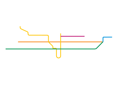
Toronto Rail Transit Map
Inspired by one of our favourites, Massimo Vignelli, we designed a map of rail transit in Toronto operated by the TTC (subways and streetcars)

Every Building in the GTHA
Heavily inspired by the New York Times’ incredible A Map of Every Building in America, we have created Every Building in the Greater Toronto and Hamilton Area (GTHA).

The Amalgamation of Toronto
This map is based on the City of Toronto’s Annexation Map. The City of Toronto Archives have a high quality digital version of it here.
Wikipedia has a detailed timeline of Toronto’s amalgamation and annexations between 1791 and today. This map was made possible because of Mapbox, Turf, and QGIS.

The Fruit Trees of Toronto
We selected, grouped and mapped the City of Toronto street trees that produce delicious (or at least edible) fruit. The species identified accounted for 22,124 trees or 3.8% of the more than half a million trees on public streets.

17 years of the Toronto Waterfront Marathon
Entering its 18th year, the Scotiabank Toronto Waterfront Marathon is one of the most important in North America. We thought it would be interesting to look at the growth of the marathon using the historical marathon results.


Trinity Bellwoods Finder
A simple tool to help plan meet ups in Trinity Bellwoods Park
The Newest TTC Map: On Paper vs. Reality
I was always curious, when looking up at the TTC's subway map, what it actually looked like. I ended up recreating it to scale one day and was surprised by the response. Since the TTC is updating the map, I thought I would take another look at it, but with some analysis this time. Using Bernhard Jenny's MapAnalyst I was able to create a deformation grid over top of the subway map.

The Yellowbelt
A brief look at stable neighbourhoods in the City of Toronto